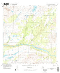
1951 Map of Talkeetna Mountains D-3
USGS Topo · Published 1975About this map
The Susitna River carves a deep valley through this Alaskan wilderness, serving as the dominant geographic landmark in a region defined by its complex hydrologic network. Surveyed from aerial photographs taken in 1949 and field-annotated by 1951, the map captures a landscape largely untouched by infrastructure, where the Seward Meridian provides the primary cartographic reference for unsurveyed lands. Glacial and alpine water systems are prominent, including the scattered Fog Lakes and the drainage of Fog Creek. In the northern half of the quadrangle, Deadman Creek and Watana Creek wind through high-elevation terrain before descending toward the river valley. The absence of roads or permanent settlements in this mid-century survey highlights the area's isolation, characterized only by the names given to these vital water bodies like Big Lake and Delusion Creek.
Find a feature on this map
8 named features on this map. Tap any name to fly to it.
Don’t see what you’re looking for? This feature index may not catch every label — zoom into the map to look around manually.
Map Details
Editions of this 1951 Talkeetna Mountains D-3 Map
3 editions found
Other maps of this area

1950 · Talkeetna Mountains
USGS Topo · 1:250,000

1950 · Healy A-3
USGS Topo · 1:63,360

1950 · Healy A-4
USGS Topo · 1:63,360

1951 · Healy
USGS Topo · 1:250,000

1951 · Talkeetna Mountains C-2
USGS Topo · 1:63,360

1951 · Talkeetna Mountains D-2
USGS Topo · 1:63,360

1951 · Talkeetna Mountains C-4
USGS Topo · 1:63,360

1951 · Talkeetna Mountains D-3
USGS Topo · 1:63,360

1951 · Talkeetna Mountains D-4
USGS Topo · 1:63,360

1951 · Talkeetna Mountains C-3
USGS Topo · 1:63,360