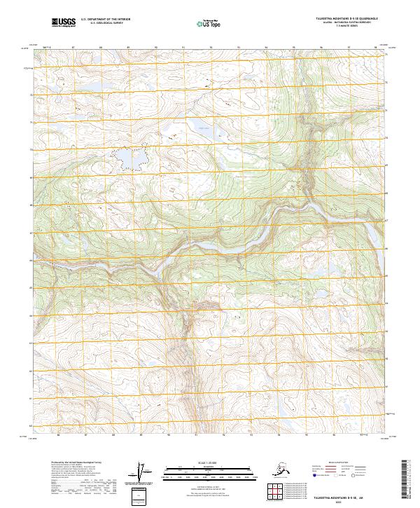
2023 Map of Talkeetna Mountains D-5 SE
USGS Topo · Published 2023About this map
Susitna River carves a dramatic path through this section of the Matanuska-Susitna region, defined by the sharp constriction of Devils Canyon. This 2023 survey by the U.S. Geological Survey captures the untouched drainage patterns of the upper basin, where the main river is joined by significant tributaries including Devil Creek and Chinook Creek. The landscape is dominated by high-altitude hydrology, anchored by High Lake in the northern reaches of the quadrangle. As a modern topographic record, the map details the exact contours of these waterways before any potential future developments alter the character of this wilderness corridor. The absence of roads or permanent structures reflects the area's continued status as a remote natural waterway system within the Talkeetna Mountains.
Find a feature on this map
9 named features on this map. Tap any name to fly to it.
Don’t see what you’re looking for? This feature index may not catch every label — zoom into the map to look around manually.
Map Details
Editions of this 2023 Talkeetna Mountains D-5 SE Map
This is the sole edition of this map. No revisions or reprints were ever made.
Other maps of this area

1950 · Talkeetna Mountains
USGS Topo · 1:250,000

1950 · Talkeetna Mountains D-5
USGS Topo · 1:63,360

1950 · Talkeetna Mountains C-5
USGS Topo · 1:63,360

1951 · Talkeetna Mountains D-5
USGS Topo · 1:63,360

1951 · Talkeetna Mountains C-4
USGS Topo · 1:63,360

1951 · Talkeetna Mountains D-4
USGS Topo · 1:63,360
1952 · Talkeetna Mountains C-5
USGS Topo · 1:63,360
1952 · Talkeetna Mountains D-4
USGS Topo · 1:63,360
1952 · Talkeetna Mountains C-4
USGS Topo · 1:63,360

1954 · Talkeetna Mountains
USGS Topo · 1:250,000