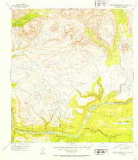
1952 Map of Talkeetna Mountains D-4
USGS Topo · Published 1953About this map
The Susitna River carves a massive course through this subarctic wilderness, its winding path defining the lower half of the territory. Surveyed in the early 1950s using multiplex methods from 1949 aerial photography, the map documents a landscape dominated by complex drainage systems and high-altitude benchmarks. Water features such as Portage Creek and Devil Creek flow from the northern heights toward the primary river valley, while the eastern section is marked by the distinct profile of Tsusena Butte and the braided waters of Tsusena Creek. To the southeast, the Fog Lakes cluster near Fog Creek, indicating a lower-lying basin amidst the surrounding peaks. This survey serves as a vital record of the Matanuska-Susitna region's topography before significant modern development, preserving the exact locations of survey markers like VABM 3780 Devil and the untouched natural drainage patterns of the era.
Find a feature on this map
9 named features on this map. Tap any name to fly to it.
Don’t see what you’re looking for? This feature index may not catch every label — zoom into the map to look around manually.
Map Details
Editions of this 1952 Talkeetna Mountains D-4 Map
2 editions found
Other maps of this area

1950 · Talkeetna Mountains
USGS Topo · 1:250,000

1950 · Talkeetna Mountains D-5
USGS Topo · 1:63,360

1950 · Healy A-3
USGS Topo · 1:63,360

1950 · Healy A-4
USGS Topo · 1:63,360

1950 · Healy A-5
USGS Topo · 1:63,360

1950 · Talkeetna Mountains C-5
USGS Topo · 1:63,360

1951 · Healy
USGS Topo · 1:250,000

1951 · Talkeetna Mountains D-5
USGS Topo · 1:63,360

1951 · Talkeetna Mountains C-4
USGS Topo · 1:63,360

1951 · Talkeetna Mountains D-3
USGS Topo · 1:63,360