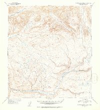
1952 Map of Talkeetna Mountains D-4
USGS Topo · Published 1953About this map
The Susitna River carves a massive glacial valley across this section of the Alaska interior, serving as the dominant geographic feature for the region during the early 1950s. The landscape is defined by its complex drainage network, where tributaries such as Devil Creek and Portage Creek flow into the main river channel from the high peaks. To the east, the Fog Lakes sit on a high plateau above Fog Creek, illustrating the glacial remnants common in this judicial division. The survey includes distinctive triangulation landmarks like VABM 3780 Devil and the prominent Tsusena Butte, which were critical for the 1952 topographic mapping. This map captures the territory before modern development, focusing on the natural water systems and the high-elevation terrain that characterizes the Talkeetna Mountains.
Find a feature on this map
9 named features on this map. Tap any name to fly to it.
Don’t see what you’re looking for? This feature index may not catch every label — zoom into the map to look around manually.
Map Details
Editions of this 1952 Talkeetna Mountains D-4 Map
2 editions found
Other maps of this area

1950 · Talkeetna Mountains
USGS Topo · 1:250,000

1950 · Talkeetna Mountains D-5
USGS Topo · 1:63,360

1950 · Healy A-3
USGS Topo · 1:63,360

1950 · Healy A-4
USGS Topo · 1:63,360

1950 · Healy A-5
USGS Topo · 1:63,360

1950 · Talkeetna Mountains C-5
USGS Topo · 1:63,360

1951 · Healy
USGS Topo · 1:250,000

1951 · Talkeetna Mountains D-5
USGS Topo · 1:63,360

1951 · Talkeetna Mountains C-4
USGS Topo · 1:63,360

1951 · Talkeetna Mountains D-3
USGS Topo · 1:63,360