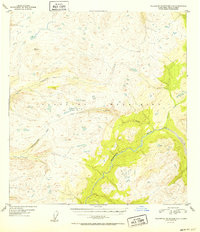
1952 Map of Talkeetna Mountains C-5
USGS Topo · Published 1952About this map
The Talkeetna River carves through the southeast quadrant of this 1952 topographic survey, serving as the primary drainage for a landscape defined by the high elevations of the Talkeetna Mountains. Based on aerial photography from 1949, this map illustrates a wilderness dominated by complex water systems and steep relief. Significant tributaries such as Chunilna Creek, Cache Creek, and Prairie Creek define the varied drainage patterns, while the aptly named Disappointment Creek winds through the southwestern corner. The mapping of VABM 4149 Clear indicates a established vertical control station used for the survey, situated among unnamed peaks that rise above 4,000 feet. The absence of roads or permanent settlements in this period emphasizes the area's isolation within the Third Judicial Division before modern development altered the region's accessibility.
Find a feature on this map
7 named features on this map. Tap any name to fly to it.
Don’t see what you’re looking for? This feature index may not catch every label — zoom into the map to look around manually.
Map Details
Editions of this 1952 Talkeetna Mountains C-5 Map
2 editions found
Other maps of this area

1949 · Talkeetna Mountains D-6
USGS Topo · 1:63,360

1949 · Talkeetna Mountains B-6
USGS Topo · 1:63,360

1949 · Talkeetna Mountains C-6
USGS Topo · 1:63,360

1950 · Talkeetna Mountains
USGS Topo · 1:250,000

1950 · Talkeetna Mountains B-5
USGS Topo · 1:63,360

1950 · Talkeetna Mountains B-4
USGS Topo · 1:63,360

1950 · Talkeetna Mountains D-5
USGS Topo · 1:63,360

1950 · Talkeetna Mountains C-5
USGS Topo · 1:63,360

1951 · Talkeetna Mountains D-5
USGS Topo · 1:63,360

1951 · Talkeetna Mountains C-4
USGS Topo · 1:63,360