
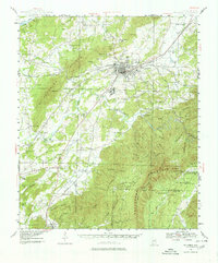
1943 Map of Talladega
USGS Topo · Published 1972About this map
Talladega serves as a regional hub in this early 1940s landscape, positioned where the Southern and Louisville and Nashville railroads intersect. The town is surrounded by a dense network of rural communities and specialized institutions, including the County Training School to the north and the textile-related settlement of Bemisston. The terrain is dominated by the massive ridge of Talladega Mountain to the southeast and Logan Martin Mountain in the west, which channel the flow of Talladega Creek and its many tributaries.
Find a feature on this map
66 named features on this map. Tap any name to fly to it.
Don’t see what you’re looking for? This feature index may not catch every label — zoom into the map to look around manually.
Map Details
Editions of this 1943 Talladega Map
2 editions found
Other maps of this area

1889 · Springville
USGS Topo · 1:125,000

1890 · Talladega
USGS Topo · 1:125,000

1891 · Ashland
USGS Topo · 1:125,000

1892 · Springville
USGS Topo · 1:125,000

1892 · Talladega
USGS Topo · 1:125,000

1900 · Anniston
USGS Topo · 1:125,000

1915 · Gantts Quarry
USGS Topo · 1:48,000

1917 · Gantts Quarry
USGS Topo · 1:62,500

1944 · Goodwater
USGS Topo · 1:62,500

1946 · Talladega
USGS Topo · 1:62,500