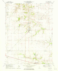
1971 Map of Tallula
USGS Topo · Published 1973About this map
The town of Tallula serves as the central hub of this Central Illinois landscape, situated at the junction of several rolling creek systems in the early 1970s. The map illustrates a region defined by its agricultural layout and the strategic pathways of the Gulf Mobile and Ohio and Baltimore and Ohio railroads. These rail lines bisect the prairie, connecting smaller nodes like Ashland and Pleasant Plains to the larger regional economy.
Find a feature on this map
21 named features on this map. Tap any name to fly to it.
Don’t see what you’re looking for? This feature index may not catch every label — zoom into the map to look around manually.
Map Details
Editions of this 1971 Tallula Map
This is the sole edition of this map. No revisions or reprints were ever made.
Other maps of this area

1909 · Tallula
USGS Topo · 1:62,500

1930 · Chandlerville
USGS Topo · 1:62,500

1932 · Chandlerville
USGS Topo · 1:62,500

1932 · Virginia
USGS Topo · 1:62,500

1933 · Petersburg
USGS Topo · 1:62,500

1936 · Virginia
USGS Topo · 1:62,500

1938 · Petersburg
USGS Topo · 1:62,500

1940 · Tallula
USGS Topo · 1:62,500

1948 · Quincy
USGS Topo · 1:250,000

1956 · Quincy
USGS Topo · 1:250,000