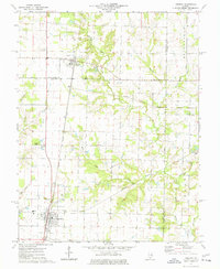
1975 Map of Tamaroa
USGS Topo · Published 1977About this map
The Tamaroa Oil Field serves as a central industrial feature on this mid-1970s survey, illustrating the intersection of energy extraction and agricultural life in Southern Illinois. The village of Tamaroa sits at the junction of two major rail lines, the Illinois Central Gulf and the Missouri Pacific, highlighting its role as a transportation hub. Northward, the settlement of Du Bois is situated along the same rail corridor, surrounded by numerous family-named burial grounds like St Charles Cem and Chapel Hill Cem. The landscape is defined by the winding course of the Little Muddy River and its tributaries, including Collier Creek and Eaton Creek. Rural education is marked by the presence of School No 211, while the southern end of the sheet includes High Sch and a prominent Radio Tower.
Find a feature on this map
40 named features on this map. Tap any name to fly to it.
Don’t see what you’re looking for? This feature index may not catch every label — zoom into the map to look around manually.
Map Details
Editions of this 1975 Tamaroa Map
This is the sole edition of this map. No revisions or reprints were ever made.
Other maps of this area

1924 · Pinckneyville
USGS Topo · 1:62,500

1926 · Pinckneyville
USGS Topo · 1:62,500

1926 · Duquoin
USGS Topo · 1:62,500

1931 · Hoyleton
USGS Topo · 1:48,000

1932 · Nashville
USGS Topo · 1:62,500

1936 · Nashville
USGS Topo · 1:62,500

1943 · Ashley
USGS Topo · 1:62,500

1946 · Ashley
USGS Topo · 1:62,500

1958 · Belleville
USGS Topo · 1:250,000

1962 · Belleville
USGS Topo · 1:250,000