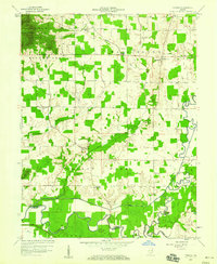
1959 Map of Tampico
USGS Topo · Published 1965About this map
Tampico and Dudleytown serve as the primary hubs of this rural Indiana landscape, which is heavily defined by the meandering waters of the Muscatatuck River and its East Fork. The southern border of the map follows the river's winding path through bottomlands marked by an extensive drainage system, including the prominent Grassy Fork and several unnamed Ditches. The map reveals a high concentration of institutional landmarks critical for genealogical research, such as Russell Chapel, Sauers Sch, and Emanuel Sch. These locations, alongside cemeteries like Mt Pleasant Cem and Lubker Cem, reflect the tight-knit settlement patterns of Washington and Brownstown townships. To the northwest, the terrain rises into the Jackson-Washington State Forest, offering a sharp contrast to the level agricultural fields and systematic ditching found near Pond Creek and Horse Lick.
Find a feature on this map
23 named features on this map. Tap any name to fly to it.
Don’t see what you’re looking for? This feature index may not catch every label — zoom into the map to look around manually.
Map Details
Editions of this 1959 Tampico Map
3 editions found

Other maps of this area

1947 · Scottsburg
USGS Topo · 1:24,000

1953 · Kossuth
USGS Topo · 1:24,000

1956 · Vincennes
USGS Topo · 1:250,000

1956 · Louisville
USGS Topo · 1:250,000

1957 · Vincennes
USGS Topo · 1:250,000

1958 · Vincennes
USGS Topo · 1:250,000

1958 · Little York
USGS Topo · 1:24,000

1958 · Brownstown
USGS Topo · 1:24,000

1958 · Seymour
USGS Topo · 1:24,000
1959 · Vallonia
USGS Topo · 1:24,000