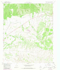
1967 Map of Tampico Siding
USGS Topo · Published 1981About this map
Fort Worth and Denver railroad tracks anchor the northern reach of this Texas Panhandle landscape, where the isolated Tampico Siding serves as a lone point of transport infrastructure amidst a complex drainage system. The terrain is defined by a dense network of erosional features, including the aptly named Oxbow Trap Canyon, Lloyd Canyon, and Mullin Canyon that feed into larger watercourses. To the south, the land transitions into the more open Wolf Flat, marked by the seasonal flow of the Wind River and a local Gravel Pit. The map captures a moment of ranching and transit in Hall County, where extensive fence lines and cattle-country markers like Buffalo Creek and Cottonwood Creek weave through the draws and canyons. This 1967 survey, with revisions noted through 1981, provides a detailed look at the rural land use and hydraulic patterns before modern agricultural shifts or road developments.
Find a feature on this map
22 named features on this map. Tap any name to fly to it.
Don’t see what you’re looking for? This feature index may not catch every label — zoom into the map to look around manually.
Map Details
Editions of this 1967 Tampico Siding Map
2 editions found
Other maps of this area

1954 · Plainview
USGS Topo · 1:250,000

1958 · Plainview
USGS Topo · 1:250,000

1960 · Brice
USGS Topo · 1:62,500

1961 · Memphis
USGS Topo · 1:62,500

1967 · North Windmill
USGS Topo · 1:24,000

1967 · Cottonwood Camp
USGS Topo · 1:24,000

1967 · Tampico Siding
USGS Topo · 1:24,000

1967 · Turkey
USGS Topo · 1:24,000

1967 · Blue Tank Canyon
USGS Topo · 1:24,000
1967 · Folley
USGS Topo · 1:24,000