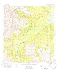
1949 Map of Tanacross A-5
USGS Topo · Published 1975About this map
Tetlin Indian Reservation occupies the eastern portion of this landscape, where the terrain transitions from the high peaks of the Alaska Range toward the Tanana River valley. The interior transport network of the late 1940s is defined by the intersection of the Glenn Highway and the historic Eagle Trail, which follows the course of the Tok River. Small roadside outposts such as Log Cabin Inn and the Clearwater Camp (Site) represent the sparse but vital settlement patterns of the era, catering to travelers along the highway. The hydrography is dominated by the glacial drainages of the Little Tok River and Clearwater Creek, while land use is marked by small-scale features like a Gravel Pit and the Eagle Trail Wayside, reflecting a region still primarily oriented around transit and indigenous lands.
Find a feature on this map
15 named features on this map. Tap any name to fly to it.
Don’t see what you’re looking for? This feature index may not catch every label — zoom into the map to look around manually.
Map Details
Editions of this 1949 Tanacross A-5 Map
2 editions found
Other maps of this area

1948 · Tanacross B-5
USGS Topo · 1:63,360

1948 · Tanacross A-6
USGS Topo · 1:63,360

1948 · Tanacross A-4
USGS Topo · 1:63,360

1948 · Nabesna D-5
USGS Topo · 1:63,360

1948 · Tanacross A-5
USGS Topo · 1:63,360

1949 · Tanacross
USGS Topo · 1:250,000

1949 · Tanacross B-4
USGS Topo · 1:63,360

1949 · Nabesna D-6
USGS Topo · 1:63,360

1949 · Tanacross A-5
USGS Topo · 1:63,360

1949 · Tanacross B-6
USGS Topo · 1:63,360