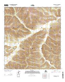
2013 Map of Tanacross B-3 SE
USGS Topo · Published 2013About this map
Ladue River meanders across this wilderness quadrangle, serving as the primary geographic feature in a landscape defined by sharp elevation changes and deep drainage basins. This 2013 survey by the U.S. Geological Survey captures the intricate topography of the Alaskan interior near the border of Townships 18 and 17 North. The absence of roads or permanent structures reflects the extreme isolation of this terrain, where the river serves as the central artery for any seasonal activity. Land survey markers for Range 16 East and Range 17 East provide the only human-imposed framework upon a region otherwise governed by the natural contours of the valley floor and high ridgelines.
Find a feature on this map
4 named features on this map. Tap any name to fly to it.
Don’t see what you’re looking for? This feature index may not catch every label — zoom into the map to look around manually.
Map Details
Editions of this 2013 Tanacross B-3 SE Map
This is the sole edition of this map. No revisions or reprints were ever made.
Other maps of this area

1948 · Tanacross A-3
USGS Topo · 1:63,360

1948 · Tanacross B-3
USGS Topo · 1:63,360

1949 · Tanacross
USGS Topo · 1:250,000

1949 · Tanacross B-3
USGS Topo · 1:63,360

1950 · Tanacross
USGS Topo · 1:250,000

1952 · Tanacross A-3
USGS Topo · 1:63,360

1952 · Tanacross B-3
USGS Topo · 1:63,360

1954 · Tanacross A-2
USGS Topo · 1:63,360

1955 · Tanacross A-2
USGS Topo · 1:63,360
1956 · Tanacross B-2
USGS Topo · 1:63,360