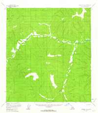
1956 Map of Tanacross B-2
USGS Topo · Published 1963About this map
The Ladue River meanders through this section of the Yukon-Tanana Uplands, defining a landscape of high-latitude drainage and isolated survey markers. This map depicts the subarctic terrain before significant human infrastructure reached this portion of the interior, focused instead on the natural hydrology of the South Fork and the surrounding marshy lowlands. Surveyors established essential horizontal control at points like Vabm Bbgm-1 3596, while identifying permafrost-related features such as a Pingo, which are characteristic of this region's geomorphology. The lack of roads or established settlements on this sheet highlights the wilderness state of the Alaskan interior in the mid-1950s, where land lines represent only unsurveyed and unmarked locations predetermined by the Bureau of Land Management.
Find a feature on this map
4 named features on this map. Tap any name to fly to it.
Don’t see what you’re looking for? This feature index may not catch every label — zoom into the map to look around manually.
Map Details
Editions of this 1956 Tanacross B-2 Map
2 editions found
Other maps of this area

1948 · Tanacross A-3
USGS Topo · 1:63,360

1948 · Tanacross B-3
USGS Topo · 1:63,360

1949 · Tanacross
USGS Topo · 1:250,000

1949 · Tanacross B-3
USGS Topo · 1:63,360

1950 · Tanacross
USGS Topo · 1:250,000

1952 · Tanacross A-3
USGS Topo · 1:63,360

1952 · Tanacross B-3
USGS Topo · 1:63,360

1952 · Tanacross A-1
USGS Topo · 1:63,360

1954 · Tanacross A-2
USGS Topo · 1:63,360

1955 · Tanacross A-2
USGS Topo · 1:63,360