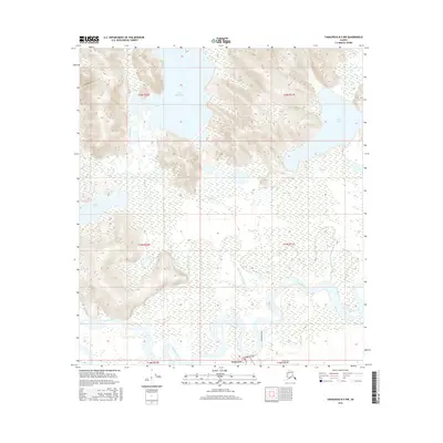
2016 Map of Tanacross B-5 NW
USGS Topo · Published 2016About this map
Tanacross serves as the focal point for this interior Alaskan landscape, situated where the broad Tanana River floodplains meet the rising highlands. The hydrography of the region is complex, defined by the winding Little Tanana Slough and a series of substantial water bodies including Lake Mansfield and Fish Lake. The terrain transitions from the low-lying wetlands surrounding Glaman Lake to the significant elevations found within the survey boundaries of T20N and T19N. Infrastructure is sparse in this part of the Unorganized Borough, with Clearwater Road providing the primary overland access toward the settlement. The intricate network of smaller tributaries, such as Little Fish Cr and Mansfield Cr, illustrates the drainage patterns that have historically shaped local travel and subsistence in the Tanana Valley.
Find a feature on this map
16 named features on this map. Tap any name to fly to it.
Don’t see what you’re looking for? This feature index may not catch every label — zoom into the map to look around manually.
Map Details
Editions of this 2016 Tanacross B-5 NW Map
This is the sole edition of this map. No revisions or reprints were ever made.
Other maps of this area

1948 · Tanacross B-5
USGS Topo · 1:63,360

1949 · Tanacross
USGS Topo · 1:250,000

1949 · Tanacross B-6
USGS Topo · 1:63,360

1950 · Tanacross
USGS Topo · 1:250,000

1951 · Tanacross B-6
USGS Topo · 1:63,360

1952 · Tanacross B-5
USGS Topo · 1:63,360

1954 · Tanacross C-6
USGS Topo · 1:63,360
1955 · Tanacross C-6
USGS Topo · 1:63,360
1956 · Tanacross C-5
USGS Topo · 1:63,360

1956 · Tanacross
USGS Topo · 1:250,000