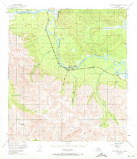
1949 Map of Tanacross B-6
USGS Topo · Published 1971About this map
Tanana River and Robertson River converge in this Alaskan interior landscape, where the Alaska Highway runs parallel to a critical Pipeline. This 1949 survey illustrates a frontier infrastructure network carved through the wilderness, including a Gaging Sta and a remote Landing Strip near Cathedral Rapids No 1. The terrain is dominated by the massive Cathedral Bluffs and high passes like Tushtena Pass in the south. Notable water features such as Moon Lake and Glaman Lake dot the lowlands, while several glacial-fed streams like Yerrick Creek and Sheep Creek drain the mountain slopes. The presence of the pipeline and the primary highway suggests the post-war strategic importance of this corridor for regional transport and resource management.
Find a feature on this map
21 named features on this map. Tap any name to fly to it.
Don’t see what you’re looking for? This feature index may not catch every label — zoom into the map to look around manually.
Map Details
Editions of this 1949 Tanacross B-6 Map
3 editions found
Other maps of this area

1948 · Tanacross B-5
USGS Topo · 1:63,360

1948 · Tanacross A-6
USGS Topo · 1:63,360

1948 · Tanacross A-5
USGS Topo · 1:63,360

1949 · Tanacross
USGS Topo · 1:250,000

1949 · Tanacross A-5
USGS Topo · 1:63,360

1949 · Tanacross B-6
USGS Topo · 1:63,360

1949 · Mt. Hayes A-1
USGS Topo · 1:63,360

1950 · Tanacross
USGS Topo · 1:250,000

1950 · Mount Hayes
USGS Topo · 1:250,000

1951 · Mount Hayes
USGS Topo · 1:250,000