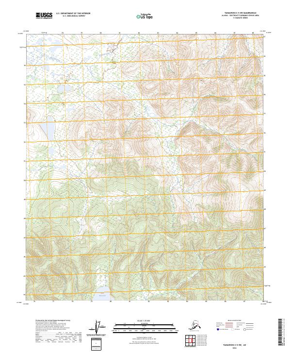
2024 Map of Tanacross C-5 SW
USGS Topo · Published 2024About this map
Mansfield Creek meanders through the northern reaches of this Southeast Fairbanks interior, carving a path through an environment defined by its hydrological patterns and varied elevation. In the southern portion of the quadrangle, Lake Mansfield sits as a prominent geographic anchor, its shoreline reflecting the complex wetlands and drainage systems that characterize the region. The map provides a detailed view of the t21n r10e, t21n r11e, t20n r10e, and t20n r11e township and range boundaries, which dictate the land division in this section of Alaska. These surveyor lines overlay a landscape where water bodies and seasonal wetlands are the primary landmarks, offering insight into the natural navigation routes used prior to modern development.
Find a feature on this map
6 named features on this map. Tap any name to fly to it.
Don’t see what you’re looking for? This feature index may not catch every label — zoom into the map to look around manually.
Map Details
Editions of this 2024 Tanacross C-5 SW Map
This is the sole edition of this map. No revisions or reprints were ever made.
Other maps of this area

1948 · Tanacross B-5
USGS Topo · 1:63,360

1949 · Tanacross
USGS Topo · 1:250,000

1949 · Tanacross B-6
USGS Topo · 1:63,360

1950 · Tanacross
USGS Topo · 1:250,000

1951 · Tanacross B-6
USGS Topo · 1:63,360

1952 · Tanacross B-5
USGS Topo · 1:63,360

1954 · Tanacross C-6
USGS Topo · 1:63,360
1955 · Tanacross C-6
USGS Topo · 1:63,360
1956 · Tanacross C-5
USGS Topo · 1:63,360

1956 · Tanacross
USGS Topo · 1:250,000