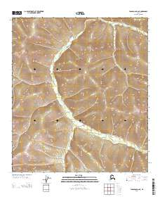
2013 Map of Tanacross D-2 NE
USGS Topo · Published 2013About this map
Liberty Cr carves a deep, winding path through the center of this terrain, serving as the primary drainage for the surrounding uplands in the Southeast Fairbanks region. The landscape is defined by a dense network of high ridges and narrow valleys, where small watercourses like Dewey Cr and Tom-Patie Cr join the larger system. The mapping of Gold-Bar Cr in the southeastern quadrant suggests a history of prospecting or localized geological interest common to this part of Alaska.
Find a feature on this map
8 named features on this map. Tap any name to fly to it.
Don’t see what you’re looking for? This feature index may not catch every label — zoom into the map to look around manually.
Map Details
Editions of this 2013 Tanacross D-2 NE Map
This is the sole edition of this map. No revisions or reprints were ever made.
Other maps of this area

1899 · Fortymile
USGS Topo · 1:250,000

1949 · Tanacross
USGS Topo · 1:250,000

1950 · Tanacross
USGS Topo · 1:250,000

1951 · Eagle
USGS Topo · 1:250,000

1956 · Tanacross D-2
USGS Topo · 1:63,360

1956 · Tanacross D-1
USGS Topo · 1:63,360

1956 · Eagle A-1
USGS Topo · 1:63,360

1956 · Eagle A-2
USGS Topo · 1:63,360

1956 · Tanacross
USGS Topo · 1:250,000

1957 · Eagle
USGS Topo · 1:250,000