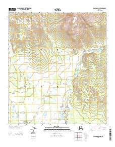
2013 Map of Tanacross D-4 NW
USGS Topo · Published 2013About this map
Kechumstuk Mountain dominates the northern reaches of this Alaskan interior terrain, where the elevation reaches over 4,600 feet before descending toward the winding Mosquito Fork. This waterway snakes through the eastern half of the sheet, carving a path through a landscape marked by numerous small ponds and marshy lowlands in the south. The presence of Mitchels Ranch along the river provides a rare point of human habitation in a region primarily defined by its drainage patterns and township boundaries, such as those meeting at the intersection of T 25 N and R 13 E. The map illustrates the isolated character of the Southeast Fairbanks area, where land use is concentrated near the few available water sources and established homesteads.
Find a feature on this map
7 named features on this map. Tap any name to fly to it.
Don’t see what you’re looking for? This feature index may not catch every label — zoom into the map to look around manually.
Map Details
Editions of this 2013 Tanacross D-4 NW Map
This is the sole edition of this map. No revisions or reprints were ever made.
Other maps of this area

1949 · Tanacross
USGS Topo · 1:250,000

1950 · Tanacross
USGS Topo · 1:250,000

1951 · Eagle
USGS Topo · 1:250,000

1956 · Tanacross D-4
USGS Topo · 1:63,360

1956 · Eagle A-5
USGS Topo · 1:63,360

1956 · Eagle A-4
USGS Topo · 1:63,360
1956 · Tanacross D-5
USGS Topo · 1:63,360

1956 · Tanacross
USGS Topo · 1:250,000

1957 · Eagle
USGS Topo · 1:250,000

1964 · Tanacross
USGS Topo · 1:250,000