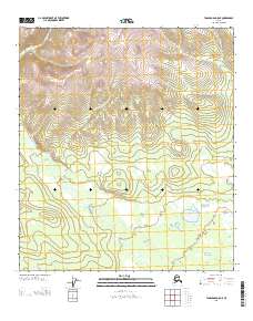
2013 Map of Tanacross D-5 NE
USGS Topo · Published 2013About this map
Mosquito Fork dominates the hydrology of this interior Alaskan landscape, meandering across the southern portion of the quadrangle. The river’s winding course and adjacent marshy lowlands contrast with the high-elevation ridges that rise to over 4,000 feet in the northern sections. This 2013 survey by the U.S. Geological Survey highlights a region defined by its isolation and lack of human infrastructure, where natural water features like Square Lake provide the only major named landmarks. The map illustrates the transition from high mountain slopes to the broad, watery basin of the fork, revealing the drainage patterns typical of the Southeast Fairbanks region.
Find a feature on this map
5 named features on this map. Tap any name to fly to it.
Don’t see what you’re looking for? This feature index may not catch every label — zoom into the map to look around manually.
Map Details
Editions of this 2013 Tanacross D-5 NE Map
This is the sole edition of this map. No revisions or reprints were ever made.
Other maps of this area

1949 · Tanacross
USGS Topo · 1:250,000

1950 · Tanacross
USGS Topo · 1:250,000

1951 · Eagle
USGS Topo · 1:250,000

1956 · Tanacross D-4
USGS Topo · 1:63,360

1956 · Eagle A-5
USGS Topo · 1:63,360

1956 · Eagle A-4
USGS Topo · 1:63,360
1956 · Tanacross D-5
USGS Topo · 1:63,360

1956 · Tanacross
USGS Topo · 1:250,000

1957 · Eagle
USGS Topo · 1:250,000

1964 · Tanacross
USGS Topo · 1:250,000