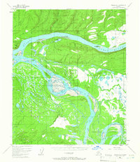
1952 Map of Tanana A-4
USGS Topo · Published 1965About this map
The Yukon River dominates this interior Alaskan landscape, shown here as a complex network of braided channels, sloughs, and seasonally shifting islands. This 1952 aerial photogrammetric survey captures the intricate hydrology of the region, where features like Eightmile Island and Tanana Slough define the river's path. Cultural markers are sparse but significant, including a Native Cem near the riverbank and a lone Cabin located north of Sixteenmile Island. The map records a wilderness infrastructure primarily consisting of a Tractor Trail winding through the northern hills and the landmark Squaw Crossing. Geomorphological features such as Mission Hill and Harper Bend provide orientation within this water-saturated terrain of oxbow lakes, including Twelvemile Lake and Horseshoe Lake, which reflect the river's long-term migration across the valley floor.
Find a feature on this map
33 named features on this map. Tap any name to fly to it.
Don’t see what you’re looking for? This feature index may not catch every label — zoom into the map to look around manually.
Map Details
Editions of this 1952 Tanana A-4 Map
3 editions found
Other maps of this area

1948 · Kantishna River
USGS Topo · 1:250,000

1951 · Kantishna River
USGS Topo · 1:250,000

1951 · Tanana
USGS Topo · 1:250,000

1952 · Tanana A-3
USGS Topo · 1:63,360

1952 · Tanana A-4
USGS Topo · 1:63,360

1952 · Kantishna River D-5
USGS Topo · 1:63,360

1952 · Kantishna River
USGS Topo · 1:250,000

1952 · Tanana A-5
USGS Topo · 1:63,360

1952 · Kantishna River D-3
USGS Topo · 1:63,360
1953 · Kantishna River D-5
USGS Topo · 1:63,360