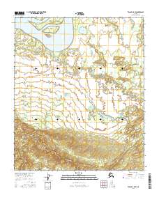
2016 Map of Tanana A-5 SW
USGS Topo · Published 2016About this map
The Yukon River dominates the northern landscape of this interior Alaska region, where the massive waterway splits around significant landforms like Tozitna Island and Circle Island. South of the main channel, the Tozitna Slough creates a complex riparian environment near Sword Point, giving way to a low-lying basin filled with smaller water bodies. This area is defined by its seasonal drainage patterns, featuring the sprawling Sixmile Lake and the meandering paths of Beaver Cr and Boney Cr. While the northern section is characterized by these intricate fluvial features and wetlands, the southern portion of the map shows a dramatic transition to higher elevations. The contour lines reveal a steep rise into upland territory, illustrating the rugged boundary between the Yukon's vast floodplains and the interior ridges.
Find a feature on this map
14 named features on this map. Tap any name to fly to it.
Don’t see what you’re looking for? This feature index may not catch every label — zoom into the map to look around manually.
Map Details
Editions of this 2016 Tanana A-5 SW Map
This is the sole edition of this map. No revisions or reprints were ever made.
Other maps of this area

1948 · Kantishna River
USGS Topo · 1:250,000

1951 · Kantishna River
USGS Topo · 1:250,000

1951 · Tanana
USGS Topo · 1:250,000

1952 · Kantishna River D-5
USGS Topo · 1:63,360

1952 · Kantishna River
USGS Topo · 1:250,000

1952 · Tanana A-6
USGS Topo · 1:63,360

1952 · Kantishna River D-6
USGS Topo · 1:63,360

1952 · Tanana A-5
USGS Topo · 1:63,360
1953 · Kantishna River D-5
USGS Topo · 1:63,360

1953 · Tanana A-5
USGS Topo · 1:63,360