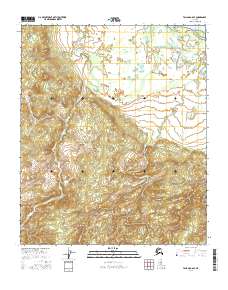
2016 Map of Tanana A-6 SE
USGS Topo · Published 2016About this map
The Yukon River defines the northeastern reaches of this interior Alaskan landscape, serving as the primary drainage for a vast network of smaller waterways. Flowing through the center and southwestern portions of the quadrangle, the Atutsak River meanders across the terrain, illustrating the complex hydrological patterns of the Yukon-Koyukuk region. In the southern and eastern sectors, Beaver Cr winds through the topography, further shaping the drainage basin. This 2016 survey, produced by the U.S. Geological Survey, uses data from the National Hydrography Dataset and National Elevation Dataset to document a wilderness area dominated by water and relief. The absence of roads or named settlements reflects the remote character of this land, where the natural watercourses remain the primary landmarks for navigation and land use study.
Find a feature on this map
12 named features on this map. Tap any name to fly to it.
Don’t see what you’re looking for? This feature index may not catch every label — zoom into the map to look around manually.
Map Details
Editions of this 2016 Tanana A-6 SE Map
This is the sole edition of this map. No revisions or reprints were ever made.
Other maps of this area

1948 · Kantishna River
USGS Topo · 1:250,000

1951 · Kantishna River
USGS Topo · 1:250,000

1951 · Tanana
USGS Topo · 1:250,000

1952 · Kantishna River D-5
USGS Topo · 1:63,360

1952 · Kantishna River
USGS Topo · 1:250,000

1952 · Tanana A-6
USGS Topo · 1:63,360

1952 · Kantishna River D-6
USGS Topo · 1:63,360

1952 · Tanana A-5
USGS Topo · 1:63,360
1953 · Kantishna River D-5
USGS Topo · 1:63,360

1953 · Tanana A-5
USGS Topo · 1:63,360