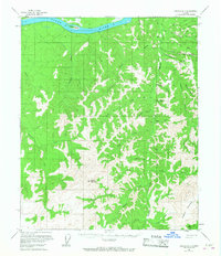
1956 Map of Tanana B-1
USGS Topo · Published 1968About this map
The Yukon River carves through the northern edge of this interior landscape, where the settlement of Rampart serves as a focal point for the region's early mining activity. As mapped in the mid-1950s, the area south of the river is defined by a dense network of gold-bearing drainages, most notably Minook Creek and its many tributaries like Hunter Creek and Little Minook Creek. These waterways are flanked by numerous named river bars, including Yukon Bar and California Bar, which point to the alluvial prospecting history that shaped this portion of the Yukon-Koyukuk.
Find a feature on this map
44 named features on this map. Tap any name to fly to it.
Don’t see what you’re looking for? This feature index may not catch every label — zoom into the map to look around manually.
Map Details
Editions of this 1956 Tanana B-1 Map
3 editions found
Other maps of this area

1945 · Livengood
USGS Topo · 1:250,000

1951 · Tanana
USGS Topo · 1:250,000

1951 · Livengood
USGS Topo · 1:250,000

1952 · Tanana A-1
USGS Topo · 1:63,360

1952 · Livengood A-6
USGS Topo · 1:63,360

1952 · Tanana A-2
USGS Topo · 1:63,360

1953 · Livengood A-6
USGS Topo · 1:63,360

1953 · Tanana A-2
USGS Topo · 1:63,360

1956 · Tanana B-1
USGS Topo · 1:63,360

1956 · Tanana C-1
USGS Topo · 1:63,360