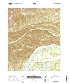
2017 Map of Tanana C-1 NE
USGS Topo · Published 2017About this map
The Yukon River dominates the lower third of this interior Alaska landscape, carving a wide path through the Yukon-Koyukuk region. This 2017 survey reveals the braided complexity of the river's south bank near the Chicago Lakes, where seasonal wetlands and smaller water bodies collect in the low-lying terrain. To the north, the elevation rises sharply away from the river valley, drained by the winding courses of Twentymile Cr and its smaller tributary, Side Cr. The aptly named Point No-Point marks a subtle bend in the river's northern shoreline, illustrating the ever-shifting nature of the water's edge in this unpopulated wilderness. The map is primarily structured by township and range lines, such as t10n r12w, reflecting the formal grid imposed on a vast and largely roadless territory.
Find a feature on this map
11 named features on this map. Tap any name to fly to it.
Don’t see what you’re looking for? This feature index may not catch every label — zoom into the map to look around manually.
Map Details
Editions of this 2017 Tanana C-1 NE Map
This is the sole edition of this map. No revisions or reprints were ever made.
Other maps of this area

1945 · Livengood
USGS Topo · 1:250,000

1951 · Tanana
USGS Topo · 1:250,000

1951 · Livengood
USGS Topo · 1:250,000

1956 · Tanana C-1
USGS Topo · 1:63,360

1956 · Livengood C-6
USGS Topo · 1:63,360

1956 · Livengood D-6
USGS Topo · 1:63,360

1956 · Tanana D-1
USGS Topo · 1:63,360

1956 · Livengood
USGS Topo · 1:250,000

1956 · Tanana
USGS Topo · 1:250,000

1960 · Tanana
USGS Topo · 1:250,000