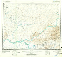
1951 Map of Tanana
USGS Topo · Published 1955About this map
The confluence of the Yukon River and Tanana River serves as the focal point for this early 1950s reconnaissance, marking a critical interior Alaskan transport hub at Tanana. The landscape is defined by the massive Ray Mountains to the north and a network of remote outposts, including McCormick Roadhouse and several shelter cabins like those at Hughes Shelter Cabin. Evidence of early 20th-century development is visible at the Agricultural Station near Rampart, while contemporary activity is noted at the Commercial Airport. To the south, the map details the mining and geothermal geography around Bean Ridge, where Placer Mines and the proximity of Manly Hot Springs indicate the region's diverse economic interests. A Winter Trail connects the scattered Cabins and settlements, reflecting the era's seasonal transit patterns before the expansion of permanent road infrastructure.
Find a feature on this map
110 named features on this map. Tap any name to fly to it.
Don’t see what you’re looking for? This feature index may not catch every label — zoom into the map to look around manually.
Map Details
Editions of this 1951 Tanana Map
3 editions found
Other maps of this area

1945 · Livengood
USGS Topo · 1:250,000

1948 · Kantishna River
USGS Topo · 1:250,000

1950 · Fairbanks
USGS Topo · 1:250,000

1951 · Kantishna River
USGS Topo · 1:250,000

1951 · Ruby
USGS Topo · 1:250,000

1951 · Fairbanks
USGS Topo · 1:250,000

1951 · Hughes
USGS Topo · 1:250,000

1951 · Melozitna
USGS Topo · 1:250,000

1951 · Bettles
USGS Topo · 1:250,000

1951 · Tanana
USGS Topo · 1:250,000