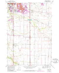
1969 Map of Tangent
USGS Topo · Published 1987About this map
The Calapooia River meanders across this mid-Willamette Valley landscape, where the agricultural community of Tangent is defined by a dense network of early transportation routes. In the late 1960s, the Southern Pacific and Oregon Electric railroads intersected the valley floor, supporting a region dotted with rural education centers like Price Sch and Oak Creek Sch. To the north, the southern expansion of Albany is visible, including the Albany Union HS and the residential development near Periwinkle Creek. The transition from historic wagon roads like Albany-Santiam Road to the modern Freeway system is evident, particularly near the Freeway Lakes County Park. Notable landmarks such as Fairview Cem and Liberty Ch provide essential touchpoints for genealogical research and local history within this productive Oregon corridor.
Find a feature on this map
49 named features on this map. Tap any name to fly to it.
Don’t see what you’re looking for? This feature index may not catch every label — zoom into the map to look around manually.
Map Details
Editions of this 1969 Tangent Map
3 editions found
Other maps of this area

1911 · Brownsville
USGS Topo · 1:31,680

1911 · Lebanon
USGS Topo · 1:31,680

1911 · Tangent
USGS Topo · 1:31,680

1912 · Jefferson
USGS Topo · 1:31,680

1912 · Halsey
USGS Topo · 1:62,500

1913 · Oakville
USGS Topo · 1:31,680

1913 · Wells
USGS Topo · 1:31,680

1916 · Albany
USGS Topo · 1:62,500

1921 · Brownsville
USGS Topo · 1:62,500

1921 · Lebanon
USGS Topo · 1:62,500