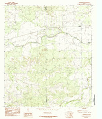
1984 Map of Tankersley
USGS Topo · Published 1984About this map
Tankersley serves as the primary settlement on this West Texas landscape, positioned just north of the winding course of Spring Creek. The 1984 survey highlights a region defined by its water resources and industrial activity, notably featuring the western edge of the Twin Buttes Reservoir. The land is segmented by the Irion Co Tom Green Co boundary, which cuts through the undulating terrain where small-scale operations like the Gravel Pit are visible. To the south, Dove Creek meanders across the plain, illustrating the drainage patterns that shaped the early ranching and agricultural development of this portion of Tom Green County. This provisional edition documents the road network and hydrological features as they existed in the mid-1980s, providing a clear record of the area's physical and administrative geography.
Find a feature on this map
6 named features on this map. Tap any name to fly to it.
Don’t see what you’re looking for? This feature index may not catch every label — zoom into the map to look around manually.
Map Details
Editions of this 1984 Tankersley Map
This is the sole edition of this map. No revisions or reprints were ever made.
Other maps of this area

1895 · Sherwood
USGS Topo · 1:125,000

1924 · Sherwood 1-d
USGS Topo · 1:48,000

1924 · Sherwood 1-a
USGS Topo · 1:48,000

1928 · Tankersly
USGS Topo · 1:62,500

1954 · San Angelo
USGS Topo · 1:250,000

1957 · Twin Buttes
USGS Topo · 1:24,000

1957 · Knickerbocker
USGS Topo · 1:62,500

1958 · San Angelo
USGS Topo · 1:250,000

1965 · San Angelo
USGS Topo · 1:250,000

1972 · Arden
USGS Topo · 1:24,000