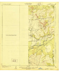
1928 Map of Tankersly
USGS Topo · Published 1928About this map
The confluence of the Middle Concho River and Spring Creek creates a complex hydrologic network in this West Texas landscape, as surveyed by W.H. Griffin and J.H. Wilke. Small agricultural hubs like Knickerbocker and Arden anchor the river valleys, while the rugged topography is punctuated by distinctive landmarks such as the Twin Buttes. The arrival of the Kansas City Mexico and Orient railroad represents a significant era of transit, cutting across the drainages of Dove Cr and the Concho River. This 1920s survey illustrates a region defined by its water sources, where early infrastructure like the Sherwood Road and San Angelo Road linked isolated ranching outposts. The detailed contouring highlights the transition from the upland plateaus down toward the South Concho River, reflecting the work of the State of Texas Board of Water Engineers in managing the area's vital river system.
Find a feature on this map
12 named features on this map. Tap any name to fly to it.
Don’t see what you’re looking for? This feature index may not catch every label — zoom into the map to look around manually.
Map Details
Editions of this 1928 Tankersly Map
3 editions found
Other maps of this area

1891 · Hayrick
USGS Topo · 1:125,000

1892 · San Angelo
USGS Topo · 1:125,000

1894 · Hayrick
USGS Topo · 1:125,000

1895 · Sherwood
USGS Topo · 1:125,000

1924 · San Angelo 2-c
USGS Topo · 1:48,000

1924 · Sherwood 1-d
USGS Topo · 1:48,000

1924 · San Angelo 2-b
USGS Topo · 1:48,000

1924 · Sherwood 1-a
USGS Topo · 1:48,000

1928 · Wall
USGS Topo · 1:62,500

1928 · Tankersly
USGS Topo · 1:62,500