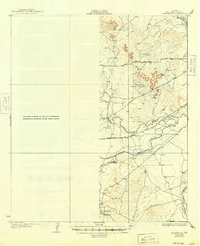
1928 Map of Tankersly
USGS Topo · Published 1949About this map
Knickerbocker sits at the southwestern edge of this West Texas landscape, positioned near the confluence of several vital watercourses. The local hydrology is the dominant feature of the terrain, where the Middle Concho River and Concho River join with Spring Creek and Dove Creek to form a complex drainage network. This area, surveyed in the mid-1920s, shows the intersection of natural landmarks like the Twin Buttes with the infrastructure of the era, most notably the Kansas City Mexico and Orient San Angelo railroad line. The map captures a transition point where the South Concho River feeds into the main river system, highlighting the critical importance of water access for early 20th-century ranching and settlement in Tom Green County. The presence of numerous bench marks along the established roads suggests a carefully documented landscape during a period of expanding regional connectivity.
Find a feature on this map
9 named features on this map. Tap any name to fly to it.
Don’t see what you’re looking for? This feature index may not catch every label — zoom into the map to look around manually.
Map Details
Editions of this 1928 Tankersly Map
3 editions found
Other maps of this area

1891 · Hayrick
USGS Topo · 1:125,000

1892 · San Angelo
USGS Topo · 1:125,000

1894 · Hayrick
USGS Topo · 1:125,000

1895 · Sherwood
USGS Topo · 1:125,000

1924 · San Angelo 2-c
USGS Topo · 1:48,000

1924 · Sherwood 1-d
USGS Topo · 1:48,000

1924 · San Angelo 2-b
USGS Topo · 1:48,000

1924 · Sherwood 1-a
USGS Topo · 1:48,000

1928 · Wall
USGS Topo · 1:62,500

1928 · Tankersly
USGS Topo · 1:62,500