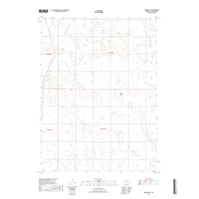
2017 Map of Tarbox Lake
USGS Topo · Published 2017About this map
Shanklin Bluff rises above the rolling sandhills and intermittent wetlands of Logan County, marking a distinct elevation change in this Nebraska landscape. The hydrology of the region is defined by the N Fork S Loup River, which meanders toward its confluence with the S Loup River in the southeastern portion of the map. This area is characterized by numerous small, seasonally-filled basins and depressions typical of the Sandhills, with Tarbox Lake serving as a more permanent water feature. Aside from Lanka Rd in the northwest, the terrain is primarily accessible via section-line tracks, reflecting a sparsely populated ranching or conservation environment organized under the Public Land Survey System townships of t19n r27w and t18n r27w.
Find a feature on this map
9 named features on this map. Tap any name to fly to it.
Don’t see what you’re looking for? This feature index may not catch every label — zoom into the map to look around manually.
Map Details
Editions of this 2017 Tarbox Lake Map
This is the sole edition of this map. No revisions or reprints were ever made.
Other maps of this area
1899 · North Platte
USGS Topo · 1:125,000
1902 · North Platte
USGS Topo · 1:125,000
1949 · Cody Lake
USGS Topo · 1:62,500

1951 · Cody Lake
USGS Topo · 1:62,500
1951 · Hoagland
USGS Topo · 1:62,500

1954 · North Platte
USGS Topo · 1:250,000

1956 · North Platte
USGS Topo · 1:250,000

1957 · North Platte
USGS Topo · 1:250,000
1967 · North Platte
USGS Topo · 1:250,000
1972 · Stapleton
USGS Topo · 1:24,000