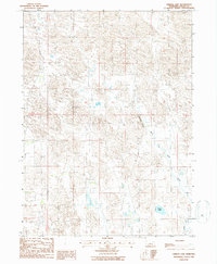
1986 Map of Tarbox Lake
USGS Topo · Published 1986About this map
Tarbox Lake and the meandering course of the South Fork Loup River dominate this pocket of Logan County as it appeared in the mid-1980s. The landscape is characterized by the complex drainage patterns of the Sandhills, where water bodies like Tarbox Lake sit within a network of intermittent streams and marshes. Notable topographic relief is found at Shanklin Bluff, which overlooks the river valley from the north. This 1986 provisional edition, based on earlier aerial photography, captures a transitional period in Nebraska ranching country, showing the minimal road infrastructure and the natural state of the river's south fork before significant modern alteration. The map provides a clear record of section lines and township boundaries, including the junction of T 19 N and T 18 N, which are essential for tracing land ownership and genealogy in this sparsely populated region.
Find a feature on this map
5 named features on this map. Tap any name to fly to it.
Don’t see what you’re looking for? This feature index may not catch every label — zoom into the map to look around manually.
Map Details
Editions of this 1986 Tarbox Lake Map
This is the sole edition of this map. No revisions or reprints were ever made.
Other maps of this area

1899 · North Platte
USGS Topo · 1:125,000

1902 · North Platte
USGS Topo · 1:125,000

1949 · Cody Lake
USGS Topo · 1:62,500

1951 · Cody Lake
USGS Topo · 1:62,500

1951 · Hoagland
USGS Topo · 1:62,500

1954 · North Platte
USGS Topo · 1:250,000

1956 · North Platte
USGS Topo · 1:250,000

1957 · North Platte
USGS Topo · 1:250,000

1967 · North Platte
USGS Topo · 1:250,000
1972 · Stapleton
USGS Topo · 1:24,000