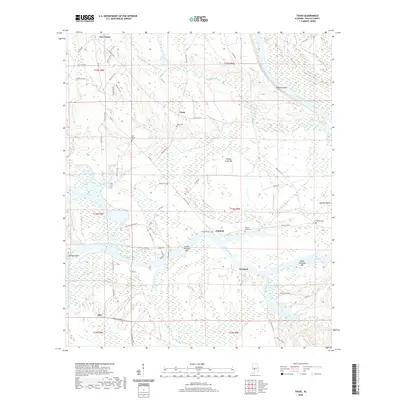
2020 Map of Tasso
USGS Topo · Published 2020About this map
The Alabama River meanders through Dallas County, shaping a landscape defined by sharp river bends and alluvial bars. Settled communities like Portland and Pinebelt occupy the high ground overlooking the water, while the rural interior is dotted with legacy family and community burial grounds, including the Seale Cem, New Bethel Cem, and Molette Cem. The river's influence is clear in the naming of topographical features such as Molette Bend and several navigation hazards like Middle Sister Bar and Lexington Bar. To the west, the Bogue Chitto Creek corridor and its associated Bogue Chitto Pkwy suggest a different drainage pattern, where Rocky Branch feeds into the larger creek system. These waterways historically dictated the placement of small crossroads such as Tasso, Ellis, and Five Points, which remain connected by a dense network of county roads.
Find a feature on this map
66 named features on this map. Tap any name to fly to it.
Don’t see what you’re looking for? This feature index may not catch every label — zoom into the map to look around manually.
Map Details
Editions of this 2020 Tasso Map
This is the sole edition of this map. No revisions or reprints were ever made.
Other maps of this area

1953 · Montgomery
USGS Topo · 1:250,000

1956 · Montgomery
USGS Topo · 1:250,000

1957 · Montgomery
USGS Topo · 1:250,000

1957 · Carlowville
USGS Topo · 1:62,500

1958 · Selma
USGS Topo · 1:62,500

1968 · Safford
USGS Topo · 1:24,000

1974 · Crumptonia
USGS Topo · 1:24,000
1974 · Camden North
USGS Topo · 1:24,000

1975 · Selma SE
USGS Topo · 1:24,000

1975 · Carlowville NE
USGS Topo · 1:24,000