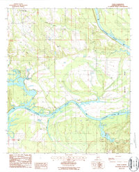
1987 Map of Tasso
USGS Topo · Published 1987About this map
The Alabama River carves a deep horseshoe through this Dallas County landscape, defining the character of the riverbottom settlements at the close of the twentieth century. Much of the southern terrain is dominated by the William "Bill" Dannelly Reservoir, where the impounded waters met the winding courses of Boque Chitto Creek and Rum Creek. This survey captures the rural infrastructure of the era, from the numerous Gravel Pits north of Tasso to the small clusters of homes at Five Points and Pinebelt.
Find a feature on this map
21 named features on this map. Tap any name to fly to it.
Don’t see what you’re looking for? This feature index may not catch every label — zoom into the map to look around manually.
Map Details
Editions of this 1987 Tasso Map
This is the sole edition of this map. No revisions or reprints were ever made.
Other maps of this area

1953 · Montgomery
USGS Topo · 1:250,000

1956 · Montgomery
USGS Topo · 1:250,000

1957 · Montgomery
USGS Topo · 1:250,000

1957 · Carlowville
USGS Topo · 1:62,500

1958 · Selma
USGS Topo · 1:62,500

1968 · Safford
USGS Topo · 1:24,000

1974 · Crumptonia
USGS Topo · 1:24,000
1974 · Camden North
USGS Topo · 1:24,000

1975 · Selma SE
USGS Topo · 1:24,000

1975 · Carlowville NE
USGS Topo · 1:24,000