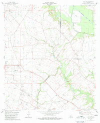
1983 Map of Tate Cove
USGS Topo · Published 1983About this map
The low-lying prairie and bayou country along the Evangeline Parish and St. Landry Parish border is defined here by a network of drainage channels and scattered agricultural settlements. Centered around Grand Prairie, the landscape is etched with the courses of Bayou Cocodrie and the engineered Bayou Boeuf-Cocodrid Diversion Channel, which manage the water levels of the surrounding farmland. Small rural hubs such as Faubourg and Tate Cove anchor the northern reaches, while the southern portion features family-named landmarks and cemeteries like Lafleur Cem and Soileaus Cem near Belair Cove. This 1980s landscape shows the transition of traditional Acadiana settlements into an era of modern infrastructure, evidenced by the Cen-Tex Landing Strip and extensive pipeline networks serving local oil wells. Local spiritual life is well-documented through scattered sites like St Peter Ch and New Hope Ch, reflecting the deep-rooted community structure of the region.
Find a feature on this map
29 named features on this map. Tap any name to fly to it.
Don’t see what you’re looking for? This feature index may not catch every label — zoom into the map to look around manually.
Map Details
Editions of this 1983 Tate Cove Map
2 editions found
Other maps of this area

1935 · Turkey Creek
USGS Topo · 1:62,500

1939 · Opelousas
USGS Topo · 1:62,500

1947 · Ville Platte
USGS Topo · 1:31,680

1947 · Chataignier
USGS Topo · 1:31,680

1948 · Bunkie
USGS Topo · 1:62,500

1949 · Turkey Creek
USGS Topo · 1:62,500

1952 · Lake Charles
USGS Topo · 1:250,000

1954 · Lake Charles
USGS Topo · 1:250,000

1956 · Opelousas
USGS Topo · 1:62,500

1957 · Opelousas
USGS Topo · 1:62,500