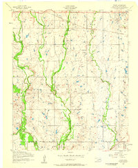
1956 Map of Taupa
USGS Topo · Published 1959About this map
St Louis San Francisco railroad tracks cut through the northern portion of this Comanche County landscape, serving the small settlement of Taupa. The area is defined by a dense network of riparian corridors, where West Cache Creek, Blue Beaver Creek, and Pecan Creek wind southward toward the Base Line. This 1950s survey captures a rural community anchored by its spiritual and commemorative sites, including Deyo Memorial Chapel and Wesley Chapel.
Find a feature on this map
16 named features on this map. Tap any name to fly to it.
Don’t see what you’re looking for? This feature index may not catch every label — zoom into the map to look around manually.
Map Details
Editions of this 1956 Taupa Map
3 editions found
Other maps of this area

1937 · Cache
USGS Topo · 1:48,000

1937 · Quanah Mountain
USGS Topo · 1:24,000

1942 · Cache
USGS Topo · 1:62,500

1946 · Lawton
USGS Topo · 1:62,500

1949 · Mount Scott
USGS Topo · 1:24,000

1949 · Quanah Mountain
USGS Topo · 1:24,000

1949 · Fort Sill
USGS Topo · 1:24,000

1955 · Lawton
USGS Topo · 1:250,000

1956 · Post Oak Creek
USGS Topo · 1:24,000
1956 · Quanah Mountain
USGS Topo · 1:24,000