
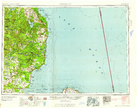
1958 Map of Tawas City
USGS Topo · Published 1958About this map
Huron National Forest dominates the landscape of this mid-century survey, showcasing a region defined by its relationship with the Lake Huron shoreline and the timber-rich interior. The map illustrates the strategic importance of the coastal strip, where the Detroit and Mackinac railroad connects essential lakefront hubs such as Tawas City, East Tawas, and Oscoda. The Cold War era presence is clearly marked by the Wurtsmith AFB and its adjacent Wurtsmith Bombing and Gunnery Range, which replaced earlier logging and fishing economies.
Find a feature on this map
114 named features on this map. Tap any name to fly to it.
Don’t see what you’re looking for? This feature index may not catch every label — zoom into the map to look around manually.
Map Details
Editions of this 1958 Tawas City Map
2 editions found
Other maps of this area

1954 · Traverse City
USGS Topo · 1:250,000

1954 · Midland
USGS Topo · 1:250,000

1954 · Flint
USGS Topo · 1:250,000

1954 · Tawas City
USGS Topo · 1:250,000

1954 · Alpena
USGS Topo · 1:250,000

1955 · Atlanta
USGS Topo · 1:62,500

1955 · Comins
USGS Topo · 1:62,500

1955 · Hillman
USGS Topo · 1:62,500

1955 · Cheboygan
USGS Topo · 1:250,000

1957 · Alpena
USGS Topo · 1:250,000