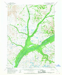
1954 Map of Taylor Mountains B-1
USGS Topo · Published 1968About this map
The Mulchatna River serves as the central artery of this interior Alaskan landscape, which was mapped by the Army Map Service using aerial photography from the mid-1950s. The drainage basin is characterized by a complex network of waterways, including the Mosquito River and the Red Bluff River, which converge amidst marshy lowlands and rising terrain. A lone Cabin located near the southern bend of the main river provides a rare indication of human presence in this otherwise wilderness region.
Find a feature on this map
8 named features on this map. Tap any name to fly to it.
Don’t see what you’re looking for? This feature index may not catch every label — zoom into the map to look around manually.
Map Details
Editions of this 1954 Taylor Mountains B-1 Map
2 editions found
Other maps of this area

1946 · Lake Clark
USGS Topo · 1:250,000

1950 · Taylor Mountains
USGS Topo · 1:250,000

1951 · Lake Clark
USGS Topo · 1:250,000

1951 · Taylor Mountains
USGS Topo · 1:250,000

1954 · Lake Clark A-8
USGS Topo · 1:63,360

1954 · Lake Clark C-8
USGS Topo · 1:63,360

1954 · Taylor Mountains
USGS Topo · 1:250,000
1954 · Taylor Mountains B-2
USGS Topo · 1:63,360

1954 · Taylor Mountains C-1
USGS Topo · 1:63,360

1954 · Taylor Mountains B-1
USGS Topo · 1:63,360