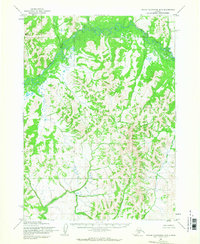
1954 Map of Taylor Mountains B-3
USGS Topo · Published 1968About this map
Nushagak River meanders across this northern interior landscape, defining the drainage patterns for a series of tributary waters including Fifteenmile Creek and Burnt Cabin Creek. The terrain is characterized by the prominent elevation of Butch Mountain in the northwest, which stands as a landmark above the complex system of river bends and surrounding lowlands. Mapped by the Army Map Service and annotated in the mid-1950s, the document reflects a period when this region was primarily accessed via its watercourses. The lower portions of the map follow the Vukpalik Creek system, illustrating the unsurveyed and unmarked land lines predetermined by the Bureau of Land Management. This topographic study captures the wilderness character of the Dillingham region before significant human infrastructure altered the natural flow of these glacial-fed interior basins.
Find a feature on this map
5 named features on this map. Tap any name to fly to it.
Don’t see what you’re looking for? This feature index may not catch every label — zoom into the map to look around manually.
Map Details
Editions of this 1954 Taylor Mountains B-3 Map
This is the sole edition of this map. No revisions or reprints were ever made.
Other maps of this area

1950 · Taylor Mountains
USGS Topo · 1:250,000

1951 · Taylor Mountains
USGS Topo · 1:250,000

1954 · Taylor Mountains
USGS Topo · 1:250,000
1954 · Taylor Mountains B-2
USGS Topo · 1:63,360

1954 · Taylor Mountains C-4
USGS Topo · 1:63,360

1954 · Taylor Mountains A-4
USGS Topo · 1:63,360

1954 · Taylor Mountains C-3
USGS Topo · 1:63,360

1954 · Taylor Mountains A-2
USGS Topo · 1:63,360
1954 · Taylor Mountains C-2
USGS Topo · 1:63,360
1954 · Taylor Mountains A-3
USGS Topo · 1:63,360