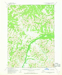
1954 Map of Taylor Mountains C-2
USGS Topo · Published 1968About this map
The Nushagak River carves a broad valley through the center of this 1954 survey, serving as the primary drainage for a landscape defined by sharp elevation shifts and dense forest cover. Mapped by the Army Map Service using photogrammetric methods from aerial photographs, the terrain is defined by the winding paths of several key tributaries. To the north, Woods Creek feeds into the main river, while Cabin Creek and Burnt Creek drain the western slopes. The lack of named settlements or roads highlights the wild character of the region during the mid-1950s, where movement was likely dictated by the seasonal flow of these watercourses. This map captures the natural hydrology of the Bristol Bay drainage basin before modern infrastructure reached these interior Alaskan mountains.
Find a feature on this map
4 named features on this map. Tap any name to fly to it.
Don’t see what you’re looking for? This feature index may not catch every label — zoom into the map to look around manually.
Map Details
Editions of this 1954 Taylor Mountains C-2 Map
2 editions found
Other maps of this area

1950 · Taylor Mountains
USGS Topo · 1:250,000

1951 · Taylor Mountains
USGS Topo · 1:250,000

1954 · Taylor Mountains
USGS Topo · 1:250,000
1954 · Taylor Mountains B-2
USGS Topo · 1:63,360

1954 · Taylor Mountains C-1
USGS Topo · 1:63,360
1954 · Taylor Mountains D-3
USGS Topo · 1:63,360

1954 · Taylor Mountains B-1
USGS Topo · 1:63,360

1954 · Taylor Mountains D-1
USGS Topo · 1:63,360

1954 · Taylor Mountains C-3
USGS Topo · 1:63,360

1954 · Taylor Mountains D-2
USGS Topo · 1:63,360