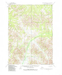
1954 Map of Taylor Mountains C-2
USGS Topo · Published 1985About this map
Nushagak River winds through the heart of this southwestern Alaska interior, serving as the primary drainage for a landscape defined by its complex hydrology and high-elevation terrain. Surveyed in the mid-1950s using aerial photography, the sheet documents the natural path of the river before modern environmental shifts. To the north and west, the tributary waters of Woods Creek and Bear Creek carve through the foothills of the Taylor Mountains, illustrating the intricate watershed patterns that have long dictated movement through this roadless region. The map provides a detailed topographic record for researchers interested in the historical geography of the Dillingham area, focusing on the preservation of natural watercourses and landforms in their mid-century state.
Find a feature on this map
3 named features on this map. Tap any name to fly to it.
Don’t see what you’re looking for? This feature index may not catch every label — zoom into the map to look around manually.
Map Details
Editions of this 1954 Taylor Mountains C-2 Map
2 editions found
Other maps of this area

1950 · Taylor Mountains
USGS Topo · 1:250,000

1951 · Taylor Mountains
USGS Topo · 1:250,000

1954 · Taylor Mountains
USGS Topo · 1:250,000
1954 · Taylor Mountains B-2
USGS Topo · 1:63,360

1954 · Taylor Mountains C-1
USGS Topo · 1:63,360
1954 · Taylor Mountains D-3
USGS Topo · 1:63,360

1954 · Taylor Mountains B-1
USGS Topo · 1:63,360

1954 · Taylor Mountains D-1
USGS Topo · 1:63,360

1954 · Taylor Mountains C-3
USGS Topo · 1:63,360

1954 · Taylor Mountains D-2
USGS Topo · 1:63,360