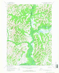
1954 Map of Taylor Mountains B-4
USGS Topo · Published 1968About this map
The Nushagak River and its major tributaries dominate this 1954 topographic study of the Taylor Mountains (B-4) region. In the northern reaches, the Chichitnok River flows south to join the Nushagak, creating a complex network of braided river channels and wetlands. The landscape is largely defined by this water-rich interior, where only a solitary Cabin suggests human activity amidst the extensive drainage systems of Klu'apuk Creek and the King Salmon River. To the northeast, Butch Mountain rises as a prominent landmark above the surrounding hills and river valleys. This map, based on aerial photography taken by the Army Map Service, captures the river-dependent character of the Dillingham area before any roads or significant settlements were established in this specific corridor.
Find a feature on this map
6 named features on this map. Tap any name to fly to it.
Don’t see what you’re looking for? This feature index may not catch every label — zoom into the map to look around manually.
Map Details
Editions of this 1954 Taylor Mountains B-4 Map
This is the sole edition of this map. No revisions or reprints were ever made.
Other maps of this area

1950 · Taylor Mountains
USGS Topo · 1:250,000

1951 · Taylor Mountains
USGS Topo · 1:250,000

1954 · Taylor Mountains
USGS Topo · 1:250,000

1954 · Taylor Mountains C-4
USGS Topo · 1:63,360

1954 · Taylor Mountains A-4
USGS Topo · 1:63,360

1954 · Taylor Mountains C-3
USGS Topo · 1:63,360

1954 · Taylor Mountains B-5
USGS Topo · 1:63,360
1954 · Taylor Mountains C-5
USGS Topo · 1:63,360
1954 · Taylor Mountains A-3
USGS Topo · 1:63,360

1954 · Taylor Mountains A-5
USGS Topo · 1:63,360