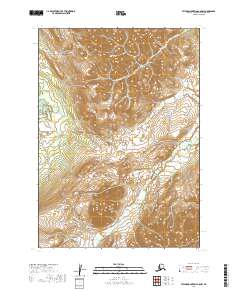
2019 Map of Taylor Mountains C-8 NW
USGS Topo · Published 2019About this map
The Kuskokwim Mountains dominate this remote interior landscape, where drainage patterns define the geography of the Dillingham Census Area. Waterways such as the Aniak River in the northwest and the Gemuk River in the south carve through the terrain, while Beaver Cr meanders across the northern sections. This 2019 survey documents the intricate network of natural drainages including Canary Gulch and Alder Gulch, providing a clear view of the wilderness topography before further environmental changes or modern infrastructure developments occur. The map's detailed contouring and Public Land Survey System boundaries, including t8n r55w and t7n r55w, offer a precise look at the township and range divisions in this largely unsettled part of Alaska.
Find a feature on this map
12 named features on this map. Tap any name to fly to it.
Don’t see what you’re looking for? This feature index may not catch every label — zoom into the map to look around manually.
Map Details
Editions of this 2019 Taylor Mountains C-8 NW Map
This is the sole edition of this map. No revisions or reprints were ever made.
Other maps of this area

1950 · Bethel
USGS Topo · 1:250,000

1950 · Taylor Mountains
USGS Topo · 1:250,000

1951 · Taylor Mountains
USGS Topo · 1:250,000

1954 · Taylor Mountains
USGS Topo · 1:250,000

1954 · Taylor Mountains D-8
USGS Topo · 1:63,360

1954 · Taylor Mountains C-8
USGS Topo · 1:63,360
1979 · Bethel D-1
USGS Topo · 1:63,360
1979 · Bethel C-1
USGS Topo · 1:63,360

1980 · Bethel
USGS Topo · 1:250,000
2019 · Bethel C-1 SE
USGS Topo · 1:25,000