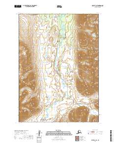
2019 Map of Bethel C-1 SE
USGS Topo · Published 2019About this map
Aniak River meanders through a broad valley floor within the Dillingham Census Area, defining the drainage patterns of this subarctic wilderness. The terrain is marked by significant elevation changes, rising toward the northeast corner where the slopes of Gemuk Mtn dominate the horizon. This 2019 survey documents a landscape nearly devoid of modern infrastructure or permanent settlements, instead focusing on the natural topography and the intricate network of wetlands and small lakes that border the river's path. The lack of roads or established trails on this sheet highlights the isolation of the Aniak River corridor, a region where the environment remains shaped primarily by the seasonal flow of water and the high relief of the surrounding mountains.
Find a feature on this map
6 named features on this map. Tap any name to fly to it.
Don’t see what you’re looking for? This feature index may not catch every label — zoom into the map to look around manually.
Map Details
Editions of this 2019 Bethel C-1 SE Map
This is the sole edition of this map. No revisions or reprints were ever made.
Other maps of this area

1950 · Bethel
USGS Topo · 1:250,000

1950 · Taylor Mountains
USGS Topo · 1:250,000

1951 · Taylor Mountains
USGS Topo · 1:250,000

1954 · Taylor Mountains
USGS Topo · 1:250,000

1954 · Taylor Mountains B-8
USGS Topo · 1:63,360

1954 · Taylor Mountains C-8
USGS Topo · 1:63,360

1979 · Bethel B-1
USGS Topo · 1:63,360
1979 · Bethel C-1
USGS Topo · 1:63,360

1980 · Bethel
USGS Topo · 1:250,000
2019 · Bethel B-1 NE
USGS Topo · 1:25,000