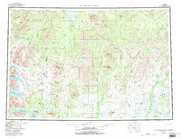
1954 Map of Taylor Mountains
USGS Topo · Published 1994About this map
The Nusha Gak Hills and Taylor Mountains define this interior Alaskan expanse, where a complex network of waterways facilitates movement through the wilderness. The western portion of the map is dominated by the interconnected waters of Wood Tikchik State Park, including Nuyakuk Lake, Chikuminuk Lake, and Lake Chauekuktuli. These large glacial lakes feed the Tikchik River, illustrating the primary drainage patterns toward the Bristol Bay region.
Find a feature on this map
64 named features on this map. Tap any name to fly to it.
Don’t see what you’re looking for? This feature index may not catch every label — zoom into the map to look around manually.
Map Details
Editions of this 1954 Taylor Mountains Map
3 editions found

Other maps of this area

1946 · Lake Clark
USGS Topo · 1:250,000

1947 · Russian Mission
USGS Topo · 1:250,000

1950 · Russian Mission
USGS Topo · 1:250,000

1950 · Sleetmute
USGS Topo · 1:250,000

1950 · Bethel
USGS Topo · 1:250,000

1950 · Taylor Mountains
USGS Topo · 1:250,000

1951 · Lake Clark
USGS Topo · 1:250,000

1951 · Taylor Mountains
USGS Topo · 1:250,000

1951 · Lime Hills
USGS Topo · 1:250,000

1951 · Dillingham
USGS Topo · 1:250,000