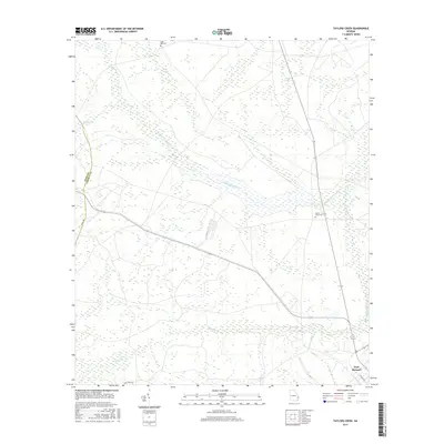
2017 Map of Taylors Creek
USGS Topo · Published 2017About this map
Fort Stewart dominates the southeastern corner of this landscape in Liberty County, where the coastal plain is defined by a dense network of blackwater tributaries and unique geological depressions. The winding course of Canoochee Creek and Canoochee Cr carves through the northern half of the territory, joined by secondary waters like Sandy Swamp and Taylors Creek. These waterways, along with Strum Bay and Cedar Bay, represent the characteristic wetland features of the Georgia Pine Barrens. Genealogists can identify significant burial sites tucked within the woods, including Todd-Ray Cem near the northern boundary and Taylors Creek Cem further east. The transition between Long County and Liberty County is marked along the western edge, near landmarks such as Strickland Pond, illustrating the sparse, rural nature of the region outside the military reservation.
Find a feature on this map
17 named features on this map. Tap any name to fly to it.
Don’t see what you’re looking for? This feature index may not catch every label — zoom into the map to look around manually.
Map Details
Editions of this 2017 Taylors Creek Map
This is the sole edition of this map. No revisions or reprints were ever made.
Other maps of this area
1918 · Hinesville
USGS Topo · 1:62,500
1919 · Claxton
USGS Topo · 1:62,500
1920 · Pembroke
USGS Topo · 1:62,500
1920 · Glennville
USGS Topo · 1:62,500
1944 · Claxton
USGS Topo · 1:62,500
1944 · Glennville
USGS Topo · 1:62,500
1944 · Hinesville
USGS Topo · 1:62,500
1946 · Brunswick
USGS Topo · 1:250,000
1947 · Savannah
USGS Topo · 1:250,000
1948 · Brunswick
USGS Topo · 1:250,000