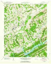
1943 Map of Tazewell
USGS Topo · Published 1964About this map
Tazewell and New Tazewell serve as the focal points of this mid-century portrait of Claiborne County, where the Dixie Highway and the Southern Railway dictate the flow of local commerce. The landscape is defined by the significant presence of the Norris Reservoir to the south, reflecting the impact of the Tennessee Valley Authority on the region's topography and drainage. This survey is particularly rich in educational and social landmarks, featuring institutions such as the Claiborne County High Sch, the Soldiers Memorial Sch, and the Rosenwald Sch. The rural character is reinforced by numerous family cemeteries like Greer Cem and Jones Cem, alongside localized infrastructure such as the Greer Tunnel and Sycamore Tunnel, which helped the railroad navigate the series of ridges including Wallen Ridge and Lone Mountain.
Find a feature on this map
92 named features on this map. Tap any name to fly to it.
Don’t see what you’re looking for? This feature index may not catch every label — zoom into the map to look around manually.
Map Details
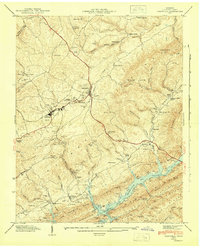
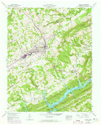
Editions of this 1943 Tazewell Map
3 editions found
Other maps of this area

1883 · Morristown
USGS Topo · 1:125,000

1886 · Cumberland Gap
USGS Topo · 1:125,000

1887 · Jonesville
USGS Topo · 1:125,000

1888 · Cumberland Gap
USGS Topo · 1:125,000

1891 · Cumberland Gap
USGS Topo · 1:125,000

1891 · Jonesville
USGS Topo · 1:125,000

1893 · Morristown
USGS Topo · 1:125,000

1895 · Morristown
USGS Topo · 1:125,000

1897 · Maynardville
USGS Topo · 1:125,000

1900 · Maynardville
USGS Topo · 1:125,000