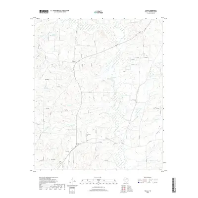
2019 Map of Tecula
USGS Topo · Published 2019About this map
The community of Mixon anchors the northern portion of this 2019 survey, situated in a region of Cherokee County defined by its rolling topography and abundant water sources. The landscape is intricately carved by streams such as W Mud Cr and Bear Cr, leading into various reservoirs like Bullard Club Lake and Greenhead Lake. Further south, the settlement of Tecula provides a key landmark, accompanied by the Tecula Cem, which serves as a significant site for genealogical research. The presence of Rocky Point and various named roads like FM 347 and Pear Ridge Rd illustrates the rural infrastructure connecting these Texas neighborhoods. This map offers a comprehensive view of the area's physical and cultural geography, highlighting the relationship between the natural drainage patterns of Birches Cr and the established human settlements in the early 21st century.
Find a feature on this map
82 named features on this map. Tap any name to fly to it.
Don’t see what you’re looking for? This feature index may not catch every label — zoom into the map to look around manually.
Map Details
Editions of this 2019 Tecula Map
This is the sole edition of this map. No revisions or reprints were ever made.
Other maps of this area
1937 · Troupe
USGS Topo · 1:48,000
1943 · Troup
USGS Topo · 1:62,500
1943 · Rusk
USGS Topo · 1:62,500
1945 · Rusk
USGS Topo · 1:62,500
1946 · Bullard
USGS Topo · 1:62,500
1948 · Bullard
USGS Topo · 1:62,500
1951 · Jacksonville
USGS Topo · 1:62,500

1953 · Palestine
USGS Topo · 1:250,000

1956 · Tyler
USGS Topo · 1:250,000

1957 · Palestine
USGS Topo · 1:250,000