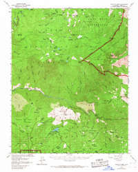
1952 Map of Tehipite Dome
USGS Topo · Published 1967About this map
Tehipite Dome towers over the Tehipite Valley in this high-altitude landscape where the Middle Fork Kings River carves through the Gorge of Despair. The map documents a critical intersection of federal lands, including the John Muir Wilderness and the Gen Grant Grove Section Kings Canyon Nat Park. In the southern reaches, the presence of numerous Sierra Redwood groves like the Converse Basin Grove and the Windy Gulch Grove highlights the area's botanical significance. Human presence is concentrated around Hume and Hume Lake, while more remote outposts like the Crown Valley Guard Station and Bartons Resort serve as waypoints for wilderness travel. Notable natural landmarks such as Boyden Cave and the massive Boole Tree stand as significant historical and recreational destinations within the Sequoia National Forest.
Find a feature on this map
103 named features on this map. Tap any name to fly to it.
Don’t see what you’re looking for? This feature index may not catch every label — zoom into the map to look around manually.
Map Details
Editions of this 1952 Tehipite Dome Map
5 editions found

Other maps of this area

1903 · Tehipite
USGS Topo · 1:125,000

1904 · Kaiser
USGS Topo · 1:125,000

1905 · Tehipite
USGS Topo · 1:125,000

1912 · Mt. Goddard
USGS Topo · 1:125,000

1922 · Trimmer
USGS Topo · 1:96,000

1924 · Dinuba
USGS Topo · 1:125,000

1942 · Dunlap
USGS Topo · 1:62,500

1944 · Dunlap
USGS Topo · 1:62,500

1947 · Mariposa
USGS Topo · 1:250,000

1948 · Fresno
USGS Topo · 1:250,000