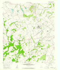
1960 Map of Tehuacana
USGS Topo · Published 1961About this map
Tehuacana stands atop a prominent ridge in Limestone County, home to the historic campus of Westminster College and the landmark Mexia State School. This 1960 survey illustrates a landscape transitioning from traditional rural settlement to an industrializing economy, evidenced by the numerous sludge pits and the Tank Farm (Allied) that contrast with the local cemetery and church network. The Navasota River and its tributaries, including Christmas Creek and Tehuacana Creek, define the topography, while several water control structures like Dam No 21 appear in the northern reaches.
Find a feature on this map
39 named features on this map. Tap any name to fly to it.
Don’t see what you’re looking for? This feature index may not catch every label — zoom into the map to look around manually.
Map Details
Editions of this 1960 Tehuacana Map
3 editions found
Other maps of this area

1920 · Mexia
USGS Topo · 1:62,500

1954 · Waco
USGS Topo · 1:250,000

1955 · Waco
USGS Topo · 1:250,000

1957 · Groesbeck
USGS Topo · 1:62,500

1960 · Echols
USGS Topo · 1:24,000

1960 · Groesbeck
USGS Topo · 1:24,000

1960 · Tehuacana
USGS Topo · 1:24,000

1963 · Wortham
USGS Topo · 1:24,000

1963 · Mexia
USGS Topo · 1:24,000

1965 · Coolidge
USGS Topo · 1:24,000