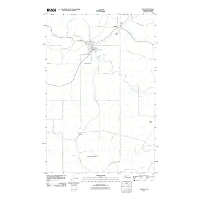
2011 Map of Tekoa
USGS Topo · Published 2011About this map
The town of Tekoa serves as the focal point of this 2011 survey, situated at the confluence of Hangman Creek and Little Hangman Creek along the border between Washington and Idaho. The landscape is defined by the agricultural transition from the Palouse hills to the rising terrain of St'umt'umm Mountain and Liberty Butte. A dense network of local roads such as Jamison Rd, Footer Rd, and Morris Rd connects isolated settlements and landmarks including Seltice, Willard, and Willard Field. Genealogists and local historians can pinpoint the Goldenrod Cemetery south of town or trace the original corridors of Tekoa Farmington Rd and State Line Rd. The map illustrates the persistent intersection of state boundaries and watercourses like Moctileme Creek and Willow Creek that have shaped the development of Whitman County and neighboring Benewah County.
Find a feature on this map
53 named features on this map. Tap any name to fly to it.
Don’t see what you’re looking for? This feature index may not catch every label — zoom into the map to look around manually.
Map Details
Editions of this 2011 Tekoa Map
This is the sole edition of this map. No revisions or reprints were ever made.
Other maps of this area

1903 · Oakesdale
USGS Topo · 1:125,000

1905 · Oakesdale
USGS Topo · 1:125,000

1954 · Fairfield
USGS Topo · 1:62,500

1955 · Spokane
USGS Topo · 1:250,000

1957 · Plummer
USGS Topo · 1:62,500

1957 · Tensed
USGS Topo · 1:62,500

1958 · Spokane
USGS Topo · 1:250,000

1964 · Oakesdale
USGS Topo · 1:24,000

1964 · Tekoa
USGS Topo · 1:24,000
1964 · Garfield
USGS Topo · 1:24,000